Conserving America’s Wetlands 2007:
Three Years of Progress
Implementing the President’s Goal
Introduction
Wetlands have long been recognized as critical to a clean, properly functioning environment and to ecosystem health. They provide a protective buffer for our towns and cities against floods and storm surges, and they provide important ecological benefits, contributing to water quality, supplying life-sustaining habitat for hundreds of species, and connecting aquatic and terrestrial ecosystems. The Nation’s wetlands provide an array of benefits to society, and their continued ability to function and thrive affects the economic, ecological, and cultural heritage of all Americans.
The importance of wetlands stewardship is reflected in the array of public–private partnerships that have formed, enhanced through efforts at the Federal level. Recognizing the need for more effective use and coordination of Federal wetlands activities, on April 22, 2004, President George W. Bush announced a new national policy on wetlands to achieve an overall increase of U.S. wetlands each year, with a goal to restore or create, improve, or protect at least three million wetland acres between Earth Day 2004 and 2009.
Three years after the President underscored the importance of wetlands, significant progress is being made toward achieving the Earth Day goal to increase overall wetlands acreage and its quality. Between Earth Day 2004 and 2007, approximately 888,000 acres have been restored or created, 1,029,000 acres have been improved, and 852,000 acres have been protected (Figure 1).
Since Earth Day 2004, the primary programs making contributions to restoration or creation are the Wetlands Reserve Program (USDA/NRCS), National Wildlife Refuge System (DOI/FWS), North American Wetlands Conservation Act (DOI/FWS), Conservation Reserve Program (USDA/FSA), and Partners for Fish and Wildlife Program (DOI/FWS). The primary contributors to the improvement goal are the National Wildlife Refuge System; Aquatic Ecosystem Restoration Program (DOA/ USACE, Civil Works); North American Wetlands Conservation Act; Conservation Technical Assistance Program (USDA/NRCS); and the Coastal Wetland Planning, Protection and Restoration Act (USACE, EPA, FWS, and NOAA). Wetlands protection through acquisitions or long-term easements is being accomplished by the North American Wetlands Conservation Act; Wetlands Reserve Program; National Wildlife Refuge System, Federal Duck Stamp Program (DOI/FWS); National Estuary Program (EPA); and Coastal Program (DOI/FWS).
Because more than 85 percent of our Nation’s wetlands are on non-Federal lands, the effectiveness of Federal efforts to improve the health, quality, and use of the Nation’s wetlands will be greatly enhanced by expanding public–private partnerships. Through cooperative conservation, the Federal Government can facilitate these partnerships by providing matching grants, technical assistance, and opportunities for the reestablishment, rehabilitation, enhancement, and protection of wetlands.
Federal agencies must continue to encourage and partner with non-Federal parties (state and local governments, tribes, and nongovernmental organizations). Well-coordinated public–private partnerships focused on wetlands opportunities will yield significant ecological benefits.

About This Report
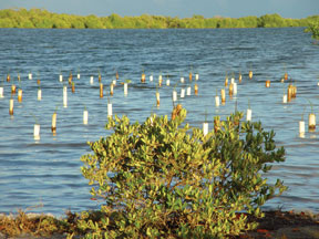 |
| Mangrove forest restoration project in Puerto Rico. (FWS) |
Conserving America’s Wetlands 2007: Three Years of Progress Implementing the President’s Goal presents a snapshot of Federal efforts to achieve the President’s goal for wetlands acreage. In providing information, the participating agencies used terminology similar to that developed by the White House Wetlands Working Group and the same terminology used in previous editions of this report. Agencies reported all notable accomplishments toward the President’s goal in the year the project was completed, or projected to be completed, rather than the year the project was funded. Adjustments were made to account for projects reported by multiple agencies (“double-counting”). Projected estimates in the 2006 report were adjusted in this year’s report as actual results became available. Appendix A provides a thorough discussion of terminology and methodology, Appendix B describes efforts that maintain the wetlands base, and Appendices C through I present program-level information and descriptions.
Accomplishments
The President's goal for wetlands has led the responsible Federal agencies to focus their resources to achieve results. Agencies do this by managing programs more strategically, leveraging resources, and partnering with others whenever possible. The following sections summarize accomplishments planned for each of the three goal areas included in the President's FY 2008 budget. Major contributing programs are identified and highlighted. Wetland Reserve accomplishments reflect the anticipated increase in the wetland enrollment acreage cap and mandatory funding under the new Farm Bill, assuming that all authorized acres are enrolled.
Restore or Create Wetlands
First Three Years of Accomplishment: 888,000 acres Estimated Accomplishment Earth Day 2008: 298,000 acres (totals adjusted for double-counting)
Wetlands can be added by creating new wetlands or by restoring former wetlands lost to drainage. New wetlands are created in upland areas or deepwater sites. A gain in wetland acres may also be achieved by re-establishing former wetlands to restore functions and values approximating natural/historic conditions. Because of difficulties in establishing wetlands in upland areas, agencies have preferred to re-establish former wetlands when possible. In many cases the necessary soils and seed stock still exist, and wetlands flourish once more as soon as the hydrology is restored.
During the first three years (April 2004 through April 2007), Federal agencies reported restoring or creating 888,000 acres of new wetlands. By Earth Day 2008, Federal agencies plan to restore or create an additional 298,000 acres of wetlands. Ninety-three percent of the gains will result from re-establishing former wetlands, and only seven percent from establishing (i.e., creating new) wetlands (primarily on upland sites).
The Federal Government will restore wetlands in FY 2008 primarily through the Wetlands Reserve Program, national Wildlife Refuge System, North American Wetlands Conservation Act, Conservation Reserve Program, and Partners for Fish and Wildlife (Figure 2).
Wetlands Reserve Program
The Wetlands Reserve Program (WRP) is administered by the USDA Natural Resources Conservation Service (NRCS). The types of wetlands restored by this program vary, from floodplain forest to prairie potholes to coastal marshes. Floodplain forest and associated sloughs and small emergent marsh wetlands account for approximately 65 percent of the program's restoration activity. A majority of the enrolled floodplain acres offered into the program occur in areas subject to frequent flooding that were originally drained or cleared for agricultural production.

WRP expects to restore or create approximately 160,000 acres of wetlands in FY 2007 and 171,000 acres in FY 2008.
National Wildlife Refuge System
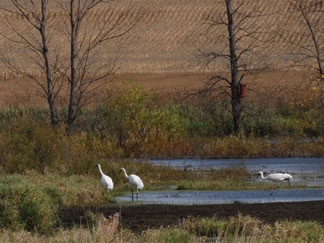 |
| Whooping cranes use a re-established wetland in north central Iowa. (Greg Hanson, Indiana Department of Natural Resources) |
The National Wildlife Refuge System restores wetlands on its lands nationwide. For example, at the Laguna Atascosa National Wildlife Refuge, Ocean Trust, the Fish and Wildlife Service, and the Natural Resources Conservation Service (USDA) are working together and with more than 60 private and public partners in south Texas to restore 10,000 acres of tidal wetlands on the refuge known as the Bahia Grande (Grand Bay). Until the mid-1930s, these wetlands served as highly productive habitats for a wide variety of fish, shellfish, waterbirds, and waterfowl. Human-caused changes to tidal pathways brought dry, sun-baked basins and over 70 years of dust to surrounding communities. In 2006, human connections and tidal connections came together to once again flood the Bahia Grande. The response was immediate-thousands of shorebirds, egrets, herons, and brown pelicans flocked to the newly flooded area to take advantage of the abundant fish.
This program expects to restore or create approximately 35,000 acres of wetlands in FY 2007 and 37,000 acres in FY 2008.
North American Wetlands Conservation Act
This FWS program promotes long-term conservation of North American wetland ecosystems for the benefit of waterfowl and other migratory birds, fish, and wildlife. Funds are provided by appropriations and by nonappropriated sources such as the Coastal Wetlands Planning, Protection and Restoration Act (CWPPRA); interest earned on Pittman Robertson Funds; and fines collected under the Migratory Bird Treaty Act.
In FY 2007, the Lower Mississippi Valley Ecosystem IV project partners will use their $1 million grant to build on their previous achievements in the landscape-scale protection, restoration, and enhancement of the alluvial valley's wetland ecosystem. In this phase, 15,238 acres of wetland habitats will be affected in the project area, with multiple conservation activities occurring on 1,970 of those acres. Project partners will protect 1,400 acres of palustrine forested wetlands in perpetuity through conservation easements donated by three private landowners in Arkansas, Louisiana, and Mississippi. Partners also will restore 5,346 acres of wetlands and enhance 8,492 acres on a mix of private and public lands in the three states, including on Louisiana's Bouef and Bayou Macon Wildlife Management Areas. The conservation easement tract in Arkansas is located close enough to the Cache River National Wildlife Refuge and Dagmar Wildlife Management Area to be in range of the ivory-billed woodpecker, a species considered extinct for the past 60 years that was recently rediscovered in the area. Other protected tracts in the project area are within the known range of the Louisiana black bear. Restoration and enhancement activities on 10,698 acres of Federal land are complementing project partners' efforts in the Lower Mississippi Alluvial Valley, and advance the habitat conservation goals of the Lower Mississippi Valley Joint Venture. Project partners are contributing $2,302,615 in matching funds and $140,000 in nonmatching other Federal dollars.
NAWCA anticipates restoring or creating approximately 37,000 acres of wetlands in FY 2007 and FY 2008.
Conservation Reserve Program
Wetlands restored through this USDA program range from prairie potholes to floodplains to bottomland hardwood forest. Currently, 1 million acres of wetlands and 1.4 million acres of associated buffers are under contract. Conservation Reserve Program wetlands successes include partnerships with states through the Conservation Reserve Enhancement Program (CREP), which has enrolled over 87,000 acres of wetlands and associated buffers. In addition, several initiatives designed to further increase wetland enrollment have been established: (1) the Non-Floodplain Wetland and Playa Lakes Restoration Initiative targets 250,000 acres for enrollment, (2) the Bottomland Timber Establishment on Wetlands Initiative has alloted 500,00 acres, and (3) the Duck Nesting Habitat Initiative is targeting 100,000 acres mostly in North and South Dakota. These wetlands provide important environmental benefits, including critical breeding habitat for ducks and grassland birds. Wildlife biologists at the Department of the Interior estimate that this program's efforts have resulted in a 30 percent increase in duck populations and significant increases in grassland bird populations on Conservation Reserve Program lands compared to cropland. The Conservation Reserve Program anticipates restoring or creating 30,000 acres of wetlands in FY 2007 and another 30,000 acres in FY 2008. Partners for Fish and Wildlife
The Partners for Fish and Wildlife Program is a popular and effective FWS program for voluntary and citizen-based wetlands restoration and enhancement activities. The Partners program serves as a bridge to owners and managers of private lands to develop partnerships for improvement of fish and wildlife populations and their habitats. Its approach is simple: engage willing partners, through nonregulatory incentives, to conserve and protect wildlife values on their property. In its 20 years, the Partners program has developed more than 41,000 private landowner agreements, re-establishing or enhancing over 800,000 acres of wetlands nationwide. As the delivery mechanism for strategic habitat conservation, the Partners program will continue to coordinate with public and private partners to reach national conservation goals. By working cooperatively with private landowners to restore and enhance habitat on private lands, the Partners program helps reduce the reliance on regulation to achieve the FWS mission of conserving Trust species and keeping common species common. Partners for Fish and Wildlife anticipates restoring or creating approximately 15,000 acres of wetlands in FY 2007 and 17,000 acres in FY 2008.
Improve Wetlands
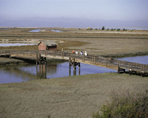 |
| More than 15,000 acres of former commercial salt ponds are being rehabilitated in San Francisco Bay, California. (FWS) |
First Three Years of Accomplishment: 1,029,000 acres
Estimated Accomplishment Earth Day 2008: 521,000 acres
(totals adjusted for double-counting)
Some degraded wetlands do not function properly because of past or present stressors. Agencies can improve wetlands by modifying the physical, chemical, or biological characteristics of a degraded wetland site with the goal of repairing its natural/historic functions and associated values (referred to as rehabilitation). They also can modify the physical, chemical, or biological site characteristics to heighten, intensify, or improve specific functions or to change the growth stage or composition of vegetation. These actions are taken with a specific goal in mind, such as improving water quality, floodwater retention, or wildlife habitat. This type of improvement, called enhancement, results in a change in wetland functions and associated values, may lead to a decline in other wetland functions and values, and does not result in a gain in wetland acres.
Between Earth Day 2004 and 2007, Federal agencies estimated improving the quality of 1,029,000 acres of existing wetlands. By Earth Day 2008, Federal agencies plan to improve the quality and associated values of an additional 521,000 acres of existing wetlands. Of the third-year improvements, 14 percent of the gains in wetlands quality will result from rehabilitating the natural/historic functions and associated values of degraded wetlands, and the remaining 86 percent will come from enhancing specific functions and values.
The major programs that are planning FY 2008 wetland improvements include the National Wildlife Refuge System; Coastal Wetlands Planning, Protection and Restoration Act; North American Wetlands Conservation Act; and Conservation Technical Assistance Program (Figure 3).

National Wildlife Refuge System
National Wildlife Refuges focus on management purposes and wildlife goals that depend on healthy wetland habitats. Over the past two centuries, more than 85 percent of San Francisco Bay's rich tidal marshes were destroyed by development, agricultural practices, and commercial salt production. This dramatic decline significantly reduced the populations of marsh-dependent fish and wildlife species, including the endangered California clapper rail and salt marsh harvest mouse. In 2006, through a series of carefully formulated and executed levee breaches, the Fish and Wildlife Service reintroduced San Francisco Bay water to the Island Ponds near Alviso, California. The effort heralded a major step forward in the ambitious 15,100-acre South Bay Salt Pond Restoration Project, the largest tidal wetland restoration project ever undertaken on the West Coast. The South Bay Project will create a network of tidal marshes and ponds for wildlife, and provide public access for wildlife viewing and recreation. The project will restore the bay's tidal wetlands as habitat for endangered species, waterfowl, and migrating and wintering shorebirds, and filter pollution, inhibit nutrient runoff, and provide flood protection.
Since the initial restoration activities have begun and pond salinity has been reduced, Refuge staff have already observed a 100 percent increase in waterfowl and a 130 percent increase in shorebirds' use of these ponds. The three goals of the long-term restoration plan are to restore habitat, improve flood protection, and increase public access and wildlife-dependent recreation in the South Bay. This wetland rehabilitation is critical to ensuring the vitality of this region and the Pacific Flyway (flyways are the routes followed by migratory birds). The Western Hemispheric Shorebird Reserve Network has designated the area as a Shorebird Reserve of Hemispheric Importance. It is the most important estuary along the West Coast for migrating shorebirds.
In FY 2007, the National Wildlife Refuge System expects to improve approximately 109,000 acres of wetlands, and an additional 114,000 acres in FY 2008.
Coastal Wetlands Planning, Protection and Restoration Act
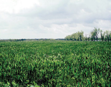 |
| Jonathan Davis Wetland Restoration, using a freshwater diversion in the north end of Barataria Bay, Louisiana. (NRCS) |
The Coastal Wetlands, Planning, Protection and Restoration Act was passed to acquire, restore, and enhance wetlands of coastal states and the trust territories. The Jonathan Davis Wetland Restoration project started in 1998 and will be completed in 2008 by NRCS and the Louisiana Department of Natural Resources. This Coastal Wetlands Planning, Protection and Restoration Act project lies between the northern, freshwater portion of the Barataria Basin and the southern, brackish/saline portion. As land is lost to the south, salinity intrudes northward through bayous and canals. The Jonathan Davis area also lies at the northern end of Bayous Perot and Rigolettes, where wave action causes shoreline erosion. Several plugs and weirs were built to reduce tidal exchange and prevent salinity increase. Bank protection was constructed along the southern boundary to prevent marsh loss. Over the 20-year project life, 510 net acres of marsh will be conserved that otherwise would have been lost with no action. A total of 4,753 acres of marsh will be enhanced by increasing the growth of common plant species, such as bull tongue. Fish and wildlife habitat will be improved and there will be some increase in birds, mammals, and fish. The project will cost $29 million, including monitoring.
Coastal Wetlands Planning, Protection and Restoration Act projects are expected to improve approximately 72,000 acres of wetlands in FY 2007, and 101,000 acres in FY 2008.
North American Wetlands Conservation Act
NAWCA grants are awarded to improvement projects that modify a functioning wetland ecosystem to provide additional long-term wetland conservation benefits. The Northern San Joaquin Valley in California, with its internationally important wetlands, is a significant site for migratory shorebirds and waterfowl. It provides wintering or stopover habitat to an estimated 60 percent of the Pacific Flyway's waterfowl population, or 20 percent of the continental population overall. Some 90 percent of California's historic 5 million acres of wetlands are now gone, and those that remain are threatened by ever-encroaching urban development and agriculture.
North San Joaquin Valley Wetland Habitat Phase II Project partners will use their $1 million NAWCA grant to improve and protect 16,304 acres of wetlands and associated riparian and upland habitats on private and public lands in three of the Central Valley Joint Venture's focus areas. Private and public partners will restore 507 acres and enhance 14,916 acres more by employing various water control techniques in wetland areas, planting riparian trees, and seeding uplands. Conservation easements will be acquired on 761 acres of habitat, and another 120 acres will be purchased. The California Waterfowl Association will secure 30-year management agreements with the 10 private landowners participating in the project. At least 13 Federally and state listed endangered or threatened species will benefit from partners' efforts. Project partners are contributing $2,829,225 in matching funds and $138,761 in nonmatching funds. NAWCA expects to improve approximately 87,000 acres of wetlands in FY 2007 and FY 2008. Conservation Technical Assistance
The broad purpose of NRCS's Conservation Technical Assistance (CTA) program is to help private landowners, conservation districts, tribes, and other organizations by providing technical assistance through a national network of locally respected, technically skilled, professional conservationists. These conservationists deliver consistent, science-based, site-specific solutions to help private landowners conserve, maintain, and improve the Nation's natural resource base. The CTA program provides the foundation for NRCS to assist farmers, ranchers, other landowners, local groups, tribes, and local governments to plan and implement natural resource conservation systems.
In FY 2006, CTA was the major source of technical assistance for planning and applying conservation practices and systems to protect and enhance natural resources on non-Federal land. These conservation actions deliver public benefits in the form of better soil quality, reduced delivery of sediment and nutrients to surface and ground waters, increased conservation of water supplies, healthier grazing and forest land ecosystems, diverse and healthier wildlife habitat, and improved wetlands condition and function.
CTA expects to improve approximately 49,000 acres of wetlands in FY 2007 and FY 2008.
Protect Wetlands
First Three Years of Accomplishment: 852,000 acres Estimated Accomplishment Earth Day 2008: 227,000 acres (totals adjusted for double-counting)
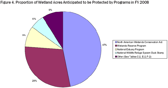
Priority wetlands can be protected from activities that may imperil their existence or condition. In this report, protection refers to acquisition of land or easements of at least 30 years. Because protection maintains the base of existing wetlands, it does not result in a gain of wetland acres or function. During the first two years of the President's Wetlands Initiative, Federal actions protected 601,000 acres of existing wetlands. In the third year, Federal agencies estimated they protected an additional 251,000 acres. By Earth Day 2008, Federal agencies plan to protect an additional 227,000 acres of wetlands. The major programs planning wetland protection in FY 2008 are the North American Wetlands Conservation Act, Wetlands Reserve Program, National Estuary Program, and National Wildlife Refuge System Federal Duck Stamp Program (Figure 4).
North American Wetlands Conservation Act
NAWCA projects often involve partnerships of state and local governments and nongovernmental and private organizations seeking to acquire wetland habitat. These acquisitions may be incorporated into the FWS National Wildlife Refuge System or into a state's protected area system, or they may be included in holdings protected by a nonprofit conservation organization (e.g., The Nature Conservancy).
One such project was the Hamilton Ridge Tract in Hampton County, South Carolina. In addition to their $1 million NAWCA grant, partners in the Savannah River Conservation Initiative/Hamilton Ridge Tract Project will use $2.1 million in matching funds and $20.1 million in nonmatching funds to acquire and protect the 13,281-acre Hamilton Ridge Tract. This tract contains 8.5 miles of frontage along the Savannah River and is located within the South Lowcountry Focus Area of the Atlantic Coast Joint Venture. The owner of the tract, International Paper Corporation, recently offered the property at a bargain price to project partners. As a result of timely collaboration and action, this land will be permanently protected as wildlife habitat instead of being sold to the highest bidder on the open market. The State of South Carolina will own the property, which is adjacent to a combined 12,600 acres of already protected habitat-the Webb and Palachucola Wildlife Management Areas. The project property contains 6,584 acres of wetlands and 6,697 acres of upland habitat, primarily loblolly pine, and will be incorporated into South Carolina's Wildlife Management Area Program for public recreational uses.
This program expects to protect approximately 145,000 acres of wetlands in FY 2007 and FY 2008.
Wetlands Reserve Program
This voluntary program provides technical and financial assistance to eligible landowners to address wetland, wildlife habitat, soil, water, and related natural resource concerns on private lands. The program provides financial incentives for landowners to restore, protect, and enhance wetlands in exchange for retiring marginal land from agriculture. Enrollment options include permanent easements, 30-year easements, and restoration cost-share agreements.
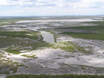 |
| Wetlands purchased in the Nueces River Delta of the Coastal Bend area near Corpus Christi, Texas. (EPA) |
The Wetlands Reserve Program (WRP) was reauthorized in the Farm Security and Rural Investment Act of 2002 (Farm Bill). The program is administered by NRCS and funded by the Commodity Credit Corporation. In FY 2005, NRCS state offices secured 751 easements on approximately 134,200 acres. NRCS is especially proud of the partnership efforts that have been generated as a result of this program's activities. For example, some 95 acres of land used for cranberry production in Plymouth, Massachusetts, will remain open space thanks to the NRCS and a partnership of landowners, local and Federal agencies, and nonprofit organizations. Through WRP, NRCS contributed more than $300,000 toward conservation easements, construction for the restoration of the stream and surrounding wetlands, and other associated costs. Partners included two private landowners, the town of Plymouth, The Nature Conservancy, the Wildlands Trust of Southeastern Massachusetts, the Cape Cod Cranberry Growers Association, the Hornblower Foundation, the Sheehan Family Foundation, and local residents.
NRCS is also proud of WRP's contributions toward restoring rare and unusual wetland communities that have been all but lost through past conversion to non-wetland uses. For example, in Sumter, South Carolina, the Booth family entered into a permanent easement to restore hydrology to a 100-acre area that was drained for row crops during the 1930s. The protected area is a Carolina Bay, a unique elliptical wetland depression found only along the coastal regions of North and South Carolina. The origin of these unique wetlands has long been the center of debate and remains a mystery. Today, only 10 percent of the original bays remain, having been drained by loggers and farmers, but programs like the Wetlands Reserve Program provide funding to landowners to restore and protect these areas.
In FY 2007, WRP expects to protect approximately 98,000 acres of wetlands, and an additional 90,000 acres in FY 2008.
National Estuary Program
At the 28 National Estuary Program (NEP) sites around the country, local stakeholders work together to identify and prioritize the problems in their estuaries. NEP community stakeholders include citizens; educators; government representatives at the state, local, and Federal levels; environmental advocates; business leaders; scientists; farmers; and people who fish. Each community develops and implements a Comprehensive Conservation and Management Plan with specific actions designed to protect the estuary and its resources. The plan addresses all aspects of environmental protection for the estuary, including water quality, habitat, living resources, and land use practices, which leads to restoration/creation, improvement, and protection activities including land protection and acquisition projects.
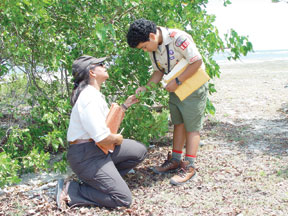 |
| U.S. Fish and Wildlife Service biologist discusses wetland restoration with a Boy Scout in Puerto Rico. (FWS) |
For example, the Nueces River Delta, Texas, contains a diverse array of coastal marsh and prairie habitats, including salt marshes, freshwater marshes and lakes, mudflats, fringe riparian corridors, and uplands. The delta provides habitat for several species of concern, including the brown pelican, least tern, and snowy and piping plover. Development throughout the Coastal Bend area near Corpus Christi, Texas, is resulting in the loss, degradation, and fragmentation of crucial habitat and a decline in the abundance and diversity of our living resources. The Coastal Bend Bays and Estuaries Program (CBBEP) helps ensure that these crucial habitats will exist for decades to come through continued habitat acquisition in the delta. CBBEP first implemented this habitat acquisition initiative in 2002, and to date has acquired approximately 5,400 acres in the Nueces River Delta. In FY 2006 alone, CBBEP protected approximately 2,500 acres. CBBEP continues negotiations with landowners, and is nearing completion of preliminary activities (survey and appraisal) needed to begin negotiations for the acquisition of another 5,100 acres in the delta.
NEP expects to protect approximately 29,000 acres of wetlands in FY 2007 and FY 2008.
National Wildlife Refuge System (Federal Duck Stamp Program)
The U.S. Fish and Wildlife Service Federal Duck Stamp Program acquires wetlands and associated habitats from willing sellers to benefit waterfowl species and other migratory birds most in need of habitat protection. FWS focuses its efforts on migratory bird breeding areas, resting places, and wintering areas under the authority of the Migratory Bird Conservation Act and the Migratory Bird Hunting and Conservation Stamp Act ("Duck Stamp"). Many of the lands and interests acquired are small natural wetlands located in the Prairie Pothole region of the Upper Midwest portion of the Central Flyway. Wetlands and migratory bird habitats located within the Atlantic, Mississippi, and Pacific Flyways are also targeted. A recent acquisition in Linn County, Oregon, added 36 acres to the William L. Finley National Wildlife Refuge, thereby protecting these acres in perpetuity. The Refuge is located within the Willamette Valley floodplain and its primary focus is to provide wintering habitat for dusky Canada geese and other waterfowl.
Migratory Bird Conservation Funds will be used to protect approximately 18,000 acres of wetlands in FY 2007 and FY 2008.


