
- Afghanistan
- Africa
- Budget Management
- Defense
- Economy
- Education
- Energy
- Environment
- Global Diplomacy
- Health Care
- Homeland Security
- Immigration
- International Trade
- Iraq
- Judicial Nominations
- Middle East
- National Security
- Veterans
- President's Cabinet
- USA Freedom Corps
- Faith-Based & Community Initiatives
- Office of Management and Budget
- National Security Council
- USA.gov
|
Welcome to "Ask the White House" -- an online interactive forum where you can submit questions to Administration Officials and friends of the White House. Visit the "Ask the White House" archives to read other discussions with White House officials.
|
|
 Dr. Louis Uccellini
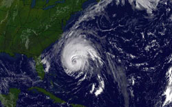
Hello. It's great to be here to answer questions about the potential dangers of Hurricane Isabel in particular, and about hurricane forecasting in general. NOAA predicted an above normal Atlantic hurricane season for 2003 and we're certainly on track.
 Rob, from Atlanta, Georgia writes:
How do hurricanes get their name?
Dr. Louis Uccellini
Names for hurricanes and tropical storms are assigned through an international committee at the World Meteorological Organization. Names have been selected through 2008.
Jeff, from London, England writes:
Dear Sir,
Thanks for giving up your time to take part in this on-line discussion. I have two questions for you.
1. Why is it that hurricanes always go north-west to the USA, Caribbean and Central America and not north-east to Europe?
2. Why is it that even the most violent of hurricanes always look so peaceful from orbit? I've never seen a storm rotating on TV.
Yours sincerely
Jeff
Jeff
Dr. Louis Uccellini
Thanks for the questions. Hurricanes generally form far enough south in the Atlantic that they are in the zone of winds directed from east to west. And therefore move generally toward the west as they cross the Atlantic basin. However, the storms can turn to the north anywhere in the Atlantic but most often do in the western part of the Atlantic Ocean basin.
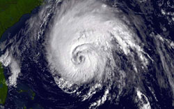
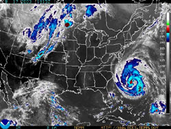
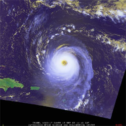
#2 -- satellite and radar imagery do show the rotation of these storms and can be seen on TV.
 Diana, from North Carolina writes:
What determines the categories of hurricanes -- this one has gone from a 5 to
a 4 to now a 2.
Dr. Louis Uccellini
Thanks. Hurricane categories are determined by the strength of sustained winds. Category one has a range of 74 - 95 mph, category two has a range from 96 - 110 mph, category three has a range of 111 - 130 mph, category four has a range of 131 - 155 and category five is higher than 155mph.
Hurricane Isabel had winds as high as 160 mph over the weekend and now has winds of 110.
Current forecasts have the storm being at least 110 mph as it approaches landfall tomorrow morning. The most recent data and forecasts of the storm can be found at the National Hurricane Center at www.nhc.noaa.gov
Frank, from Boulder, CO
writes:
Is there any international coordination on forecasting storms?
Thanks!
Dr. Louis Uccellini
Hi Frank
The answer is yes, there is coordination amongst many countries in the Caribbean and Canada as these storms approach these areas.
james, from oklahoma writes:
will the hurrricane produce any rain for the plains states?
Dr. Louis Uccellini
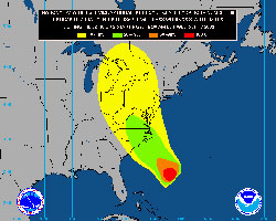
The maximum rainfall for Hurricane Isabel is expected east of the Appalachian mountains on a line from eastern North Carolina up through central Pennsylvania to western New York. There might be some rain that gets into Ohio and Kentucky but no rain is expected from this system in the plains.
There have been examples where a hurricane moving into the plains states from the Gulf of Mexico has brought rain into the southeastern U.S.
There are also hurricanes that come in from the west Pacific through the Gulf of California that produce rain in the southwest into the central plains.
 lori, from gresham or writes:
Is there anyway with prediction of the weather that it can be controled in
any way? Or do people just have to react to what is comming.
Dr. Louis Uccellini
There is no way to control these types of storm systems. What NOAA does is to improve the predictive capabilities of their forecast systems such as numerical models to provide better prediction of the track up to five days in advance and intensity. Given the improved prediction the emergency management community including FEMA then takes action to mitigate the impacts of these storms on communities up and down the coast and inland.
At 72 hours we are now able to predict the location of these storms within 185 miles and within five days we are able to predict these storms within 300 miles.
These breakthroughs in predictive capabilities commenced in the mid 1980s with the upgrades in global and local numerical models and the implementation of very high speed computers. And we continue to make progress as we upgrade the computers and introduce high-resolution models which can make use of the global satellite observing system that the U.S. and other countries have invested hundreds of millions of dollars in.
Alison, from Florida writes:
Where is Hurrican Isabel headed?
 Dr. Louis Uccellini
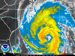
Isabel is heading for the Outer Banks of North Carolina and will make landfall just south of Cape Hatteras on Thursday morning. From there the storm is expected to track through Central Virginia through west-central Pennsylvania by late Friday morning. While the hurricane will lose its strength as it moves inland we expect the storm to accelerate so that the winds will be strong as it approaches Pennsylvania but not hurricane force. The main problem for central Pennsylvania will be the heavy rainfall which could exceed 6 inches in the southern part of the state near Hagerstown, Maryland.
William, from Washington, DC writes:
Hello: What are typical types of damage caused to single-famliy homes during a
strong hurricane such as Isabel? What is the worst I should expect in DC? my
house is brick, no basement, and located in Silver Spring, MD. Should I be
concerned?
Thanks!

|

|
The storm track is now expected to be a bit further west of the DC area. DC should still receive heavy rains from this with amounts of up to 6 inches possible. The DC area should experience strong gusty winds Thursday night through early Friday morning as the center of the storm passes west with winds from 35 to 60 mph possible just west of the city.
The biggest problem for the DC area could be the storm surge up the Potomac River as the storm moves into central Virginia. The exact height of the surge will be dependent on the track if the storm continues to track west, it will reduce the surge but this is something we have to watch carefully as the storm approaches DC.
In August 1933, an unnamed storm moved right towards DC from the North Carolina coast and was responsible for the largest surge recorded in the Potomac and Chesapeake Bay area.
Willie, from Virginia writes:
Can you describe what an average day is like at the Hurricane Center during a
major hurricane like Isabel? Thank you.
Dr. Louis Uccellini
The average day is a 24/7 operation. During an event like Isabel the hurricane specialists on duty are supplemented with extra staff that keep track of all data that comes in to monitor current changes, to keep track of all the new model output which projects the future track and intensity of these storms and to interact continuously with the emergency management community at the federal level and the state and local levels being affected by these storms.
One of the data sets that they pay close attention to during these events are the aircraft data derived from the hurricane hunters and the new research aircraft such as the NOAA Gulfstream IV.
It is definitely very hectic, busy yet exciting time to be in the hurricane center.
Joseph, from Angier, NC writes:
How does Isabel compare to other hurricanes to hit the Carolinas in the last
few years?
![]() Dr. Louis Uccellini
Dr. Louis Uccellini
As a category 2 storm approaching the North Carolina coast, Isabel ranks as one of the strongest storms to affect the North Carolina coast. The angle that the storm is coming into the Outer Banks has never been observed before.
Given the angle of approach to the coast at this time, and the projected strength of Isabel as it makes landfall this will be a very dangerous situation for the Outer Banks especially in the Cape Hatteras area. The reason is numerical models are indicating that wave heights greater than 45 feet on top of a surge approaching ten feet will be affecting that area of the Outer Banks.
Clearly this is a dangerous situation that the state officials are working with to enforce an evacuation of this area.
Caroline, from New Jersey writes:
Is it going to hit Burlington Township, New Jersey?
Dr. Louis Uccellini
The center of Hurricane Isabel will stay well south of New Jersey however the interaction of this hurricane with the high pressure system located over New England will create very strong pressure gradient from southern New England all the way down to North Carolina.
Because of this, we expect strong winds immediately along the coast of New Jersey approaching 35 mph and strong waves along the Jersey and Delaware coasts that could be as high as 12 feet in southern New Jersey and northern Delaware.
 Janet, from Washington, DC writes:
How many more Atlantic hurricanes can we expect this year?
Dr. Louis Uccellini
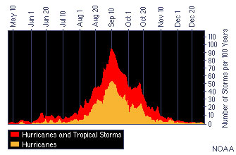
The climate prediction center forecasts for this season has 11 - 15 storms predicted with three to four of them becoming major hurricanes. To date, we've had nine named storms and two major hurricanes. The hurricane season runs through November 30.
Isabel is a reminder that no matter what number of storms develop in the Atlantic or Caribbean area, it only takes one hurricane or tropical storm to make a major impact on this country. This impact is not only in the coastal area where we expect very high waves and a strong storm surge as it makes landfall on Thursday, but that heavy rains inland can tend to create flooding conditions all the way into southwest Pennsylvania and strong winds in North Carolina, Virginia and Maryland could cause extensive tree damage as the storm moves inland and weakens on early Friday.
Cathy, from Albany, NY writes:
I know it is unusual for Hurricanes to track so far inland and maintin its
forceful impact. In this particular storm, at what point North will it
finally dissipate?
Dr. Louis Uccellini
It is not unusual for hurricanes to sustain high winds and heavy rains as it moves inland especially for those that are accelerating as they make landfall. For example, Hurricane Hugo moved across the entire state of North Carolina in 1989 with hurricane-force winds as it approached the Appalachian Mountains. For Isabel, we expect the hurricane-force winds to dissipate over the state of Virginia but to maintain damaging winds as the storm crosses western Maryland into south-central Pennsylvania.
Heavy rainfall can be expected along the track of the storm through western Pennsylvania into western New York and south-central Canada. The amount of rains in Pennsylvania, New York and Canada depends on how fast it moves through. Current projections show that 5 inches could fall as far north as Toronto.
In Albany, whatever rainfall you get should be over by Friday afternoon leaving you with a nice weekend Saturday and Sunday.
 Dave, from Delaware writes:
On a percentage basis how accurate are modern forecasters in the
prediction of storm tracks?
Dr. Louis Uccellini
At 72 hours NOAA is now predicting the location of hurricanes with an accuracy of 220 miles. This accuracy has increased from an average predictive skill of 450 miles 20 years ago. During the 20 year period, with the introduction of more powerful computers and more accurate numerical models, we have basically doubled the skill of the track, prediction and three-day time frame.
Individual storms, such as the "Perfect Storm," Hurricane Floyd in 1999 and Hurricane Claudette this year have had track forecasts predicted with skill better than the 220 miles, three, four and five days in advance.
These forecasts made three-five days in advance have proved to be very useful for mariners and the Navy to take protective steps as they are today for Isabel.
Dr. Louis Uccellini
 Thanks for everyone for visiting with me! Weather is certainly a fascinating topic and one that affects all of our lives. NOAA has many interesting things online, if you are interested in learning more, visit www.noaa.gov. For more information about hurricanes please visit us on the web at hurricanes.noaa.gov. I hope to talk to you again some time. As President Bush said, "With preparation, forecasting and coordination, we can save lives and improve our Nation's ability to withstand the impact of hurricanes."


